<& /components/TrackPage.mhtml,
version=>'2',
new=>'2005-09-05',
updated=>'',
license=>'CC-NC-SA',
author=>'Guy Watney',
owner=>'Guy Watney',
date=>'2005-2006',
oval=>'',
road=>'',
drag=>'',
kart=>'',
offroad=>'',
oval=>'',
road=>'paved,temp,airport,inactive',
drag=>'',
kart=>'',
offroad=>'',
adBeforeTOC => '',
trackName => 'Texas A&M University, Riverside Campus',
trackStreetAddr => 'Hwy 21 at Hwy 47',
trackCityState => 'Bryan, TX',
trackZip => '77807',
introduction => ', was an airport course set up on the runways of Texas A & M
Flight Test Station Airport, seven miles west of College Station, TX. Two
configurations (1.4 and 3.4 miles) were used by SCCA.
This page was contributed by Guy Watney, Kansas City Region SCCA.
',
trackOffice => '',
mapService=>'Yahoo',
foodService=>'Yahoo',
hotelService=>'Yahoo',
timeZone => 'CST/CDT (-0600/-0500)',
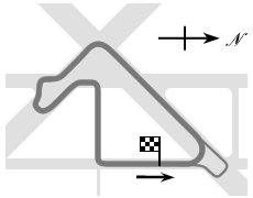
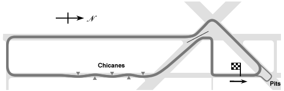
trackMap => '
The 1.4 mile course configuration was:

The 3.4 mile course configuration was:
',
trackImage => '',
terraServerLink => '
http://terraserver.microsoft.com/image.aspx?T=1&S=13&Z=14&X=463&Y=2119&W=1
',
googleMapLink => '',
historicalNote => '',
weatherID => 'USTX0170',
weatherZIP => '',
officialWebSite => '',
schedulePage => '',
resultsPage => '',
ticketsPage => '',
gettingThere => '',
racersGuide => '',
hotLap => '',
workersGuide => '',
foodInsert => '',
hotelInsert => '',
TOCInsertLink1 => '',
TOCInsertText1 => '',
TOCInsertLink2 => '',
TOCInsertText2 => '',
TOCInsertLink3 => '',
TOCInsertText3 => '',
TOCInsertLink4 => '',
TOCInsertText4 => '',
TOCInsertLink5 => '',
TOCInsertText5 => '',
TOCInsertLink6 => '',
TOCInsertText6 => '',
offsiteTOCInsertLink1 => '',
offsiteTOCInsertText1 => '',
offsiteTOCInsertLink2 => '',
offsiteTOCInsertText2 => '',
offsiteTOCInsertLink3 => '',
offsiteTOCInsertText3 => '',
offsiteTOCInsertLink4 => '',
offsiteTOCInsertText4 => '',
offsiteTOCInsertLink5 => '',
offsiteTOCInsertText5 => '',
offsiteTOCInsertLink6 => '',
offsiteTOCInsertText6 => '',
&>