<& /components/TrackPage.mhtml,
version=>'2',
new=>'2005-09-05',
updated=>'2007-09-01',
license=>'CC-NC-SA',
author=>'Guy Watney',
owner=>'Guy Watney',
date=>'2005-2007',
oval=>'paved,defunct',
road=>'paved,defunct',
drag=>'paved,quarter,defunct',
kart=>'',
offroad=>'',
adBeforeTOC => '',
trackName => 'Vaca Valley Raceway',
trackStreetAddr => 'Lewis Rd & Weber Rd',
trackCityState => 'Vacaville, CA',
trackZip => '95687',
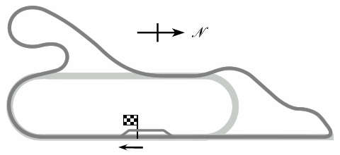
introduction => ' was a combined drag-strip, 1.25-mile oval and 2.1-mile road
race track located in Vacaville, CA. It opened in 1958 and closed in 1972.
This page was contributed by Guy Watney, Kansas City Region SCCA.
',
trackOffice => '',
mapService=>'Google',
foodService=>'Google',
hotelService=>'Google',
timeZone => 'PST/PDT (-0800/-0700)',
elevation=>'75 feet',
latitude=>'38.408339',
longitude=>'-121.899533',
trackMap => '
The track map was:
',
trackImage => '',
terraServerLink => '
http://terraserver.microsoft.com/image.aspx?T=1&S=12&Z=10&X=745&Y=5314&W=2
',
googleMapLink => 'http://maps.google.com/maps?f=q&hl=en&geocode=&q=Vacaville,+CA&ie=UTF8&ll=38.408339,-121.899533&spn=0.015436,0.027509&t=h&z=15&om=1',
historicalNote => '
The facility was an early example of what is now known as a multi-purpose
motorsports facility, combining a drag strip, oval and sports-car track.
Unfortunately, the quality of the paving was poor from the beginning and the
track closed when the surface deteriorated to the point of being
unusable. Neither the owner nor the local SCCA region were able to secure
the $15,000 required for repaving and other improvements. It is reported that
the San Francisco Region SCCA investigated re-opening the track in the early
1990s as an alternative to Sears Point (now Infineon Raceway). Local residents
objected, so they built Thunderhill instead. In as late as 2003, when the
land-use permit was still valid, the San Francisco Region again looked at the
site, but by this time the price of the land was prohibitive.
The outline of the track is still (at the time of writing) visible in aerial
photographs, but little remains at ground level other than some gravel and
isolated patches of tarmac.
',
weatherID => '',
weatherZIP => '',
officialWebSite => '',
schedulePage => '',
resultsPage => '',
ticketsPage => '',
gettingThere => '',
racersGuide => '',
hotLap => '',
workersGuide => '',
foodInsert => '',
hotelInsert => '',
TOCInsertLink1 => '',
TOCInsertText1 => '',
TOCInsertLink2 => '',
TOCInsertText2 => '',
TOCInsertLink3 => '',
TOCInsertText3 => '',
TOCInsertLink4 => '',
TOCInsertText4 => '',
TOCInsertLink5 => '',
TOCInsertText5 => '',
TOCInsertLink6 => '',
TOCInsertText6 => '',
offsiteTOCInsertLink1 => '',
offsiteTOCInsertText1 => '',
offsiteTOCInsertLink2 => '',
offsiteTOCInsertText2 => '',
offsiteTOCInsertLink3 => '',
offsiteTOCInsertText3 => '',
offsiteTOCInsertLink4 => '',
offsiteTOCInsertText4 => '',
offsiteTOCInsertLink5 => '',
offsiteTOCInsertText5 => '',
offsiteTOCInsertLink6 => '',
offsiteTOCInsertText6 => '',
&>