This page was contributed by Guy Watney, Kansas City Region SCCA.
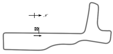
', trackOffice => '', mapService=>'Google', foodService=>'Google', hotelService=>'Google', timeZone => 'PST/PDT (-0800/-0700)', elevation=>'380 feet', latitude=>'32.903875', longitude=>'-117.248132', trackMap => ' The track map was:
Torrey Pines was located on the former Camp Callan artillery training center. The site was plowed up to make way for a golf course in the late 1950s.
', weatherID => '', weatherZIP => '', officialWebSite => '', schedulePage => '', resultsPage => '', ticketsPage => '', gettingThere => '', racersGuide => '', hotLap => '', workersGuide => '', foodInsert => '', hotelInsert => '', TOCInsertLink1 => '', TOCInsertText1 => '', TOCInsertLink2 => '', TOCInsertText2 => '', TOCInsertLink3 => '', TOCInsertText3 => '', TOCInsertLink4 => '', TOCInsertText4 => '', TOCInsertLink5 => '', TOCInsertText5 => '', TOCInsertLink6 => '', TOCInsertText6 => '', offsiteTOCInsertLink1 => '', offsiteTOCInsertText1 => '', offsiteTOCInsertLink2 => '', offsiteTOCInsertText2 => '', offsiteTOCInsertLink3 => '', offsiteTOCInsertText3 => '', offsiteTOCInsertLink4 => '', offsiteTOCInsertText4 => '', offsiteTOCInsertLink5 => '', offsiteTOCInsertText5 => '', offsiteTOCInsertLink6 => '', offsiteTOCInsertText6 => '', &>